
Climate risk modelling for Indian agriculture has emerged as one of the most critical disciplines shaping how institutions like NABARD and the World Bank design crop insurance, climate finance, and rural adaptation programmes across India. With over 60% of Indian farmland rainfed and annual agricultural losses from climate events exceeding Rs.1.5 lakh crore, quantifying climate risk is no longer optional — it is the foundation of every viable agri-finance decision in 2026. This guide covers the 8 key tools used by NABARD and the World Bank, how they work in the Indian context, career opportunities in this field, and what qualifications you need to build a high-earning career in agri climate risk analysis.
📋 Table of Contents
- Why Climate Risk Modelling Matters for Indian Agriculture
- NABARD & World Bank – Climate Risk Framework in India
- 8 Key Climate Risk Modelling Tools Used in India
- Tool 1 – DSSAT Crop Simulation Model
- Tool 2 – Satellite Remote Sensing (ISRO, NASA, ESA)
- Tool 3 – NICRA Agro-Climatic Vulnerability Mapping
- Tool 4 – PMFBY Actuarial Loss Models
- Tool 5 – Index-Based Insurance Models (RWBCI & IBLI)
- Tools 6–8 – Climate Finance & GIS Tools
- Career Opportunities & Salary in Climate Risk Modelling
- Who Should Pursue This Career?
- Frequently Asked Questions
Why Climate Risk Modelling Matters for Indian Agriculture in 2026
India loses an estimated Rs.50,000–Rs.1,50,000 crore worth of crops annually to climate-related events including drought, unseasonal rain, hailstorms, and cyclones. The economic and humanitarian stakes are enormous — agriculture employs over 42% of India’s workforce and supports 800 million rural people. Despite this, most financial instruments designed to protect farmers have historically relied on manual crop-cutting experiments (CCEs) that are slow, expensive, and geographically limited.
Climate risk modelling transforms this landscape by enabling:
- 🌡️ Probabilistic loss forecasting — quantifying the likelihood of yield loss under specific weather scenarios 30–90 days ahead
- 💧 Drought and flood early warning — triggering pre-emptive credit restructuring and insurance payouts before farmers face catastrophic loss
- 🏦 Risk-adjusted lending — helping NABARD, regional rural banks, and cooperative credit societies set climate-adjusted loan terms
- 📊 Insurance product design — powering actuarial models behind PMFBY, RWBCI, and emerging parametric insurance products
- 🌿 Climate adaptation planning — directing Rs.10,000+ crore in World Bank and Green Climate Fund investments to the most vulnerable farming districts
🗝️ Key Facts – India Agri Climate Risk at a Glance 2026
- 📌 Annual crop loss from climate events: Rs.50,000–Rs.1,50,000 crore
- 📌 Farmers covered under PMFBY 2025–26: 5.5 crore+
- 📌 NABARD climate finance portfolio: Rs.25,000 crore+
- 📌 World Bank agri-climate projects active in India: 12+
- 📌 Climate-vulnerable farming districts (NICRA): 151
- 📌 Estimated climate risk analyst jobs in India by 2027: 8,000+
NABARD & World Bank – Climate Risk Framework for Indian Agriculture
NABARD operates India’s largest rural development finance portfolio and is the primary domestic institution applying climate risk modelling to agricultural lending and insurance. In 2026, NABARD’s Climate Change Fund manages over Rs.25,000 crore in climate-linked agri-finance, using risk models to screen projects, set interest rates, and trigger contingency funds. NABARD partners with GIZ India, IFAD, and ADB to adapt global climate risk tools to India’s agro-climatic diversity.
The World Bank’s engagement in Indian agri-climate risk comes through projects like APART (Agri-business and Rural Transformation), the National Cyclone Risk Mitigation Project, and co-financing of India’s NICRA programme. The Bank applies its global Climate and Disaster Risk Screening (CDRS) framework to all India agriculture portfolio investments exceeding USD 50 million. It also funds the Global Index Insurance Facility (GIIF) which has run pilots in Andhra Pradesh, Maharashtra, and Bihar.
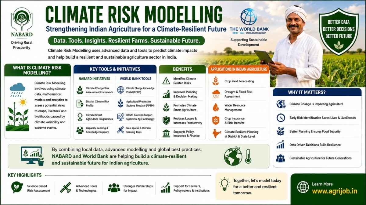
8 Key Climate Risk Modelling Tools Used in Indian Agriculture
Tool 1 – DSSAT Crop Simulation Model
DSSAT (Decision Support System for Agrotechnology Transfer) is the world’s most widely used crop growth simulation platform, covering 42 crop species including rice, wheat, maize, sorghum, and chickpea. ICAR institutes — particularly ICAR-IARI in New Delhi and ICAR-CRIDA in Hyderabad — use DSSAT to project how India’s key crops will respond to rising temperatures, shifting monsoon patterns, and elevated CO2 concentrations through 2050.
NABARD uses DSSAT outputs to model premium adequacy for crop insurance in high-risk districts. State agriculture universities in Punjab, Haryana, and Maharashtra run DSSAT for agro-advisory services. Key applications in India:
- 🌾 Modelling rice yield reduction under 1.5°C and 2°C warming scenarios for PMFBY premium recalibration
- 🌽 Simulating wheat heading date shifts from heat stress during grain-filling in Indo-Gangetic Plains
- 💧 Water productivity analysis for drought-prone zones in Vidarbha and Bundelkhand
- 📅 Optimising sowing windows for cotton and soybean in rain-shadow regions
Tool 2 – Satellite Remote Sensing (ISRO / NASA MODIS / ESA Sentinel)
Satellite remote sensing has revolutionised climate risk assessment by providing near-real-time, spatially continuous data on crop health, soil moisture, surface temperature, and flood inundation across India’s 142 million hectares of net cultivated area. Three satellite systems dominate Indian agri-climate risk work:
| Satellite System | Agency | Key Parameter | Indian Application |
|---|---|---|---|
| Resourcesat-2A / EOS-04 | ISRO | LISS-III multispectral NDVI | PMFBY crop area estimation, kharif/rabi monitoring |
| MODIS Terra/Aqua | NASA | Land surface temperature, drought index | NICRA heat stress alerts, AIC loss trigger mapping |
| Sentinel-1 / Sentinel-2 | ESA / Copernicus | SAR flood mapping, NDVI | Flood damage assessment for PMFBY claim validation |
| GRACE-FO | NASA / DLR | Groundwater depletion gravity anomaly | NABARD groundwater risk scoring for kisan credit cards |
ISRO’s National Remote Sensing Centre (NRSC) in Hyderabad generates weekly crop condition reports used by the Ministry of Agriculture, NABARD, and state governments to trigger PMFBY area-based payouts and early warning systems.
Tool 3 – NICRA Agro-Climatic Vulnerability Mapping
NICRA (National Innovations in Climate Resilient Agriculture) is an ICAR flagship network project operating across 151 climate-vulnerable districts in India. It uses a composite vulnerability index combining exposure (climate hazard frequency), sensitivity (soil type, crop dependence), and adaptive capacity (irrigation access, income) to rank India’s farming districts on a 0–1 climate vulnerability scale.
NABARD uses NICRA vulnerability scores to prioritise its Watershed Development Fund and Tribal Development Fund disbursements. World Bank project appraisals cite NICRA district vulnerability rankings to justify infrastructure investments in food-insecure regions. For field-level practitioners, NICRA’s district contingency crop plans — covering 625 districts — are the most operationally useful climate risk tool available for free in India.
Tool 4 – PMFBY Actuarial Loss Models
India’s Pradhan Mantri Fasal Bima Yojana (PMFBY) is the world’s largest crop insurance scheme by farmer enrollment, covering 5.5 crore farmers in 2025–26 with a total sum insured exceeding Rs.3.3 lakh crore. Behind PMFBY’s premium calculations lies a sophisticated actuarial loss modelling framework that integrates 25+ years of historical yield data, weather station records, and remote sensing indices.
NABARD’s empanelled actuaries and the Agriculture Insurance Company of India (AIC) use this framework to set premium rates by crop-district-season combinations. Key model components:
- 📉 Historical yield loss frequency distributions by crop and district (1990–2025)
- 🌧️ Rainfall-yield correlation matrices from 600+ IMD weather stations
- 🌡️ Heat stress event probability curves for rabi wheat and kharif cotton
- 🛰️ Satellite-based area yield proxies replacing slow crop-cutting experiments in 12 states
- 💰 Catastrophe reinsurance loading factors for cyclone-prone coastal districts
Tool 5 – Index-Based Insurance Models (RWBCI & IBLI)
Index-based insurance eliminates the moral hazard and adverse selection problems of traditional crop insurance by paying out based on an objectively measured index — such as district-level rainfall below a trigger threshold — rather than on individual farm loss surveys. India operates 2 main index systems at scale:
Restructured Weather-Based Crop Insurance (RWBCI) pays out when a weather parameter (cumulative rainfall, temperature, relative humidity) crosses a pre-defined threshold during a crop’s critical growth phase. Actuaries design trigger levels and exit levels using 30-year historical weather-yield correlations. NABARD’s watershed project states — Maharashtra, Karnataka, Rajasthan — have the most mature RWBCI implementations.
Index-Based Livestock Insurance (IBLI), piloted by the World Bank Global Index Insurance Facility in Bihar and Rajasthan, uses satellite-derived pasture index (NDVI below threshold) to trigger payouts for pastoral communities. This is especially relevant for Bihar’s cattle-dependent smallholders who have no access to traditional livestock insurance.
Tools 6–8 – Climate Finance, GIS & Decision Support Frameworks
Tool 6 – World Bank Climate and Disaster Risk Screening (CDRS): A mandatory screening protocol applied to all World Bank investment lending in India. It uses a combination of climate hazard maps (drought, flood, cyclone, heat), exposure data (crop area, infrastructure), and vulnerability scores to assign a climate risk rating to every project component. NABARD is integrating CDRS logic into its own project appraisal manual for district-level schemes above Rs.100 crore.
Tool 7 – QGIS / ArcGIS Spatial Risk Mapping: Geographic Information System tools are used extensively by NABARD’s regional offices and World Bank project teams to overlay climate hazard layers with agricultural asset maps. Typical outputs include flood-inundation risk maps for NABARD’s infrastructure lending, drought-frequency maps for watershed project prioritisation, and district-level heat anomaly maps for PMFBY actuarial zones. ISRO’s Bhuvan platform provides free GIS layers for Indian agriculture risk work.
Tool 8 – R and Python Statistical Modelling (Climate Econometrics): Advanced statistical analysis using R packages (tidyverse, sf, ClimInd) and Python libraries (xarray, rasterio, scikit-learn) underpins the quantitative core of Indian agri-climate risk research. The World Bank Development Research Group and ICAR-CRIDA produce peer-reviewed econometric studies quantifying the impact of temperature anomalies on Indian crop yields, farmer income volatility, and rural poverty. These studies directly inform NABARD’s district credit plans and World Bank India country climate diagnostic reports.
💡 Pro Tip: If you are targeting a NABARD Grade A or World Bank consultant role in climate risk, master at least 2 of these 3 technical skills: DSSAT crop modelling, QGIS spatial analysis, or Python/R climate econometrics. Candidates who combine domain agronomy knowledge with quantitative modelling skills command Rs.20,000–Rs.40,000/month more than pure agronomists in the development finance sector.
Career Opportunities & Salary in Agri Climate Risk Modelling India 2026
The intersection of climate science and agricultural finance is generating high-value career opportunities across India’s public, multilateral, and private sectors. Here is the full salary and career landscape for climate risk modelling professionals in Indian agriculture:
| Role | Organisation | Monthly Salary (Est.) | Annual CTC |
|---|---|---|---|
| NABARD Grade A Development Assistant | NABARD | Rs.44,500 – Rs.65,000 | Rs.5.3L – Rs.7.8L |
| Climate Risk Analyst | AIC / Private Insurer | Rs.50,000 – Rs.90,000 | Rs.6L – Rs.10.8L |
| World Bank Consultant (STC) | World Bank India | Rs.80,000 – Rs.1,50,000 | Rs.9.6L – Rs.18L |
| GIZ / IFAD Programme Officer | GIZ India / IFAD | Rs.70,000 – Rs.1,20,000 | Rs.8.4L – Rs.14.4L |
| ICAR Scientist B (Agricultural Meteorology) | ICAR | Rs.56,100 – Rs.1,77,500 | Rs.6.7L – Rs.21L |
| Climate Finance Analyst (Green Bond) | Private / NBFC | Rs.60,000 – Rs.1,00,000 | Rs.7.2L – Rs.12L |
| Remote Sensing Analyst (Agri) | NRSC / ISRO / State Govt | Rs.35,000 – Rs.70,000 | Rs.4.2L – Rs.8.4L |
Who Should Pursue Climate Risk Modelling as a Career?
- 🎓 M.Sc. Agricultural Meteorology / Agronomy Graduates: Candidates from IARI, BHU, TNAU, or PAU with a strong academic grounding in crop-weather relationships are natural fits for NABARD and ICAR climate modelling roles.
- 📊 Statistics / Data Science Professionals with Agri Interest: Quantitative analysts who can work with large climate datasets in Python/R and apply spatial statistics to crop loss data are in very high demand at World Bank and multilateral agencies.
- 🌿 Environmental Science / Geography Postgraduates: Graduates skilled in GIS, remote sensing, and environmental impact assessment who want to specialise in agricultural climate risk for NRSC, ISRO, or state disaster management agencies.
- 🏦 Agriculture Finance Professionals at NABARD / RRBs: Bankers and loan officers who want to move into climate-linked credit risk roles within NABARD’s growing climate finance division.
- ⚖️ Insurance Actuaries Specialising in Agri: Actuaries and risk managers at AIC, HDFC Ergo Agri, or ICICI Lombard who price PMFBY or RWBCI products and want to deepen their climate modelling expertise.
- 🌍 Development Sector Professionals Targeting Multilateral Careers: Candidates with 3–5 years in NABARD, BRLPS, ATMA, or state agriculture departments who want to transition to World Bank, IFAD, or GIZ consultant roles at Rs.80K–Rs.1.5L/month.
- 💻 Remote Sensing Engineers at ISRO / NRSC: Spatial data scientists working on agricultural crop monitoring who want to apply their skills to climate risk insurance and PMFBY claim validation.
- 🎯 NABARD Grade A / ICAR Scientist Aspirants: Candidates preparing for competitive recruitment exams who want to build a specialisation that makes them standout in the Agriculture & Rural Development (ARD) paper.
Climate Risk Modelling vs Traditional Agri Research – Career Comparison
| Parameter | Climate Risk Modelling | Traditional Agri Research (ICAR / SAU) |
|---|---|---|
| Salary Range | Rs.50,000 – Rs.1,50,000/month | Rs.35,000 – Rs.1,00,000/month |
| Private Sector Demand | Very High (InsurTech, FinTech, NGO) | Moderate (seed, agchem companies) |
| International Opportunities | High (World Bank, CGIAR, FAO) | Moderate (CGIAR centres) |
| Tools Required | Python/R, DSSAT, GIS, climate data | Lab equipment, field experiments |
| Job Competition | Low-Moderate (niche skill) | High (large applicant pool) |
| Time to First Job | 6–18 months with right skills | 2–4 years (PhD often required) |
| Best For | Quantitative + agri domain candidates | Field research and crop improvement |
🏆 Expert Verdict: Climate risk modelling for Indian agriculture is the highest-value niche at the intersection of agronomy, data science, and finance. With PMFBY covering Rs.3.3 lakh crore in insured value, NABARD managing a Rs.25,000 crore climate portfolio, and the World Bank deploying billions in India’s agri-climate resilience space, the demand for professionals who can model, quantify, and communicate agricultural climate risk will only grow through 2030. Invest in DSSAT, Python, and QGIS skills now — the salary premium over a generalist agronomist is Rs.20,000–Rs.60,000/month.
Frequently Asked Questions – Climate Risk Modelling Indian Agriculture
What is climate risk modelling in Indian agriculture?
Climate risk modelling in Indian agriculture is the use of statistical, satellite, and crop simulation tools to quantify the probability and financial impact of weather-driven losses — including drought, flood, and heat stress — on farm production and rural livelihoods. Institutions like NABARD and the World Bank use these models to design insurance schemes, climate finance instruments, and adaptation investment plans for India’s 140 million farming households.
Which tools does NABARD use for climate risk assessment?
NABARD uses DSSAT crop simulation models, ICAR-CRIDA agro-climatic zone mapping, satellite-based NDVI monitoring, and PMFBY actuarial loss models for climate risk assessment in Indian agriculture. NABARD also partners with GIZ and IFAD to apply global climate finance frameworks — including the World Bank’s CDRS protocol — to Indian district-level lending decisions.
What is the World Bank’s role in agri climate risk India?
The World Bank supports climate risk management in Indian agriculture through the APART project, NICRA co-funding, and technical assistance for India’s National Adaptation Plan. The Bank finances district-level climate vulnerability mapping, promotes index-based livestock insurance (IBLI), and supports PMFBY reform with improved actuarial models and satellite-based loss assessment systems.
What is DSSAT and how is it used in India?
DSSAT (Decision Support System for Agrotechnology Transfer) is a crop growth simulation platform used to predict how crops like rice, wheat, and maize respond to changing temperature, rainfall, and CO2 levels. In India, ICAR institutes and state agriculture universities use DSSAT to model yield changes under future climate scenarios and inform PMFBY premium calculations and sowing advisories for farmers.
What career opportunities exist in climate risk modelling for agriculture?
Career opportunities in climate risk modelling for Indian agriculture include NABARD Grade A Development Assistant, World Bank Short-Term Consultant, ICAR Scientist posts, GIZ India Programme Officer, AIC crop insurance actuary, and climate finance analyst at green bond issuers. Monthly salaries range from Rs.45,000 for entry-level roles to Rs.1,50,000 for experienced World Bank consultants.
What is index-based crop insurance and how does it relate to climate models?
Index-based crop insurance pays out based on a measurable weather index — such as rainfall below a threshold or temperature above a critical level — rather than individual farm loss assessment. Climate risk models design these indices by establishing statistical relationships between historical weather parameters and yield losses. PMFBY and RWBCI in India both use climate risk modelling to set trigger levels and calculate actuarially sound premium rates.
What is NICRA and what does it do for Indian farmers?
NICRA (National Innovations in Climate Resilient Agriculture) is an ICAR network project covering 151 vulnerable districts in India. It uses agro-climatic modelling to identify stress-tolerant varieties, water-saving practices, and climate-adaptive livestock management. NABARD uses NICRA district vulnerability scores to prioritise watershed development and tribal development fund investments in the most at-risk farming zones.
What salary does a climate risk analyst earn in India in 2026?
A climate risk analyst in India working with NABARD, World Bank, or GIZ can earn Rs.50,000 to Rs.1,50,000 per month. NABARD Grade A officers start at Rs.44,500/month with annual increments. World Bank Short-Term Consultant roles pay Rs.80,000 to Rs.1,20,000/month. Senior consultants on IFAD or ADB projects can earn Rs.1.5 lakh to Rs.2.5 lakh/month on longer-term contracts.
How does satellite remote sensing help in agri climate risk modelling?
Satellite remote sensing provides real-time, area-wide data on crop health (NDVI), soil moisture, flood extent, and drought severity across millions of hectares simultaneously. ISRO’s Resourcesat, NASA’s MODIS, and ESA’s Sentinel satellites are used by NABARD, AIC, and state governments to trigger index-based insurance payouts, validate PMFBY claims, and monitor early warning alerts for drought and flood-affected districts.
What qualifications are needed for agri climate risk jobs in India?
Jobs in climate risk modelling for Indian agriculture typically require a postgraduate degree in Agricultural Meteorology, Agronomy, Environmental Science, Statistics, or Agricultural Economics. Proficiency in R, Python, GIS tools (QGIS, ArcGIS), and crop simulation software (DSSAT, ORYZA) is essential. Candidates with hands-on NABARD, ICAR, or World Bank project experience are strongly preferred by multilateral agencies and private sector employers.
This guide is regularly reviewed and updated for accuracy. Bookmark this page for the latest updates on climate risk modelling careers and NABARD recruitment 2026.
Last Updated: May 2026