
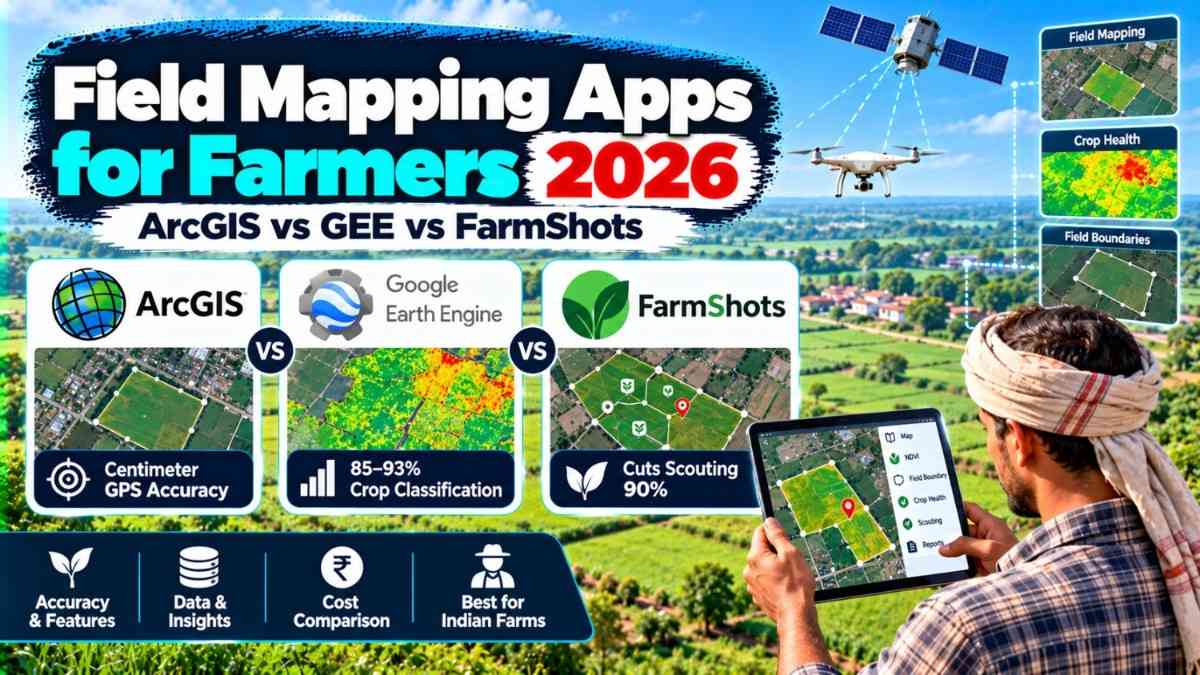
The best field mapping app for farmers in 2026 depends on farm size and budget. ArcGIS Field Maps delivers centimeter-level GPS accuracy for large enterprise farms, Google Earth Engine provides free cloud-scale crop classification at 85–93% accuracy for research and FPOs, while FarmShots (now under Syngenta) reduces field scouting time by up to 90% using high-resolution satellite NDVI imagery — making it the fastest option for mid-sized commercial farms.
Field mapping apps for farmers in 2026 are no longer optional tools — they are the foundation of every profitable precision agriculture operation in India and globally. Whether you manage 2 acres of paddy in Bihar or 500 acres of cotton in Telangana, choosing the wrong mapping platform costs you yield, input money, and time. This guide directly compares the three most widely discussed field mapping platforms — ArcGIS Field Maps, Google Earth Engine (GEE), and FarmShots by Syngenta — across accuracy, cost, ease of use, and suitability for Indian smallholder and commercial farming conditions in 2026.

This guide is for Indian farmers, agricultural officers, FPO managers, agritech professionals, and agronomy students aged 18–55 who want to map their fields accurately without spending a fortune. By the end, you will know exactly which tool to use based on your farm size, technical skill, and budget — from completely free options to enterprise-grade Rs.1,50,000+/year platforms.
- ArcGIS Field Maps GPS Accuracy: Sub-meter to centimeter-level (with external GNSS receiver)
- Google Earth Engine Crop Classification Accuracy: 82–93% overall accuracy across field-level studies
- FarmShots Field Scouting Reduction: Up to 90% reduction in manual scouting time
- FarmShots Enrolled Acres (at acquisition): 8 million acres globally
- India Precision Farming Investment (Government): Rs 6,000 crore allocated for Smart Precision Horticulture Programme
- ICAR Precision Farming Centres in India: 22 centres across India under ICAR-NePPA
- Satellite Imagery Cost (Sentinel-2): Free — available every 5 days
- Drone Mapping Cost India (2026): Rs 400–700 per hectare per flight pass
- Field Boundary GPS Accuracy (Smartphone): 1–3 meters (RTK: centimeter-level)
- Field Mapping Software Saving vs Traditional Survey: Up to 70% cost reduction
📋 Table of Contents
- What Is Field Mapping for Farmers and Why It Matters in 2026
- Who Should Use Field Mapping Apps?
- ArcGIS Field Maps 2026 — Features, Accuracy & Cost
- Google Earth Engine for Agriculture — Crop Mapping Accuracy
- FarmShots by Syngenta — NDVI Satellite Scouting Review
- ArcGIS vs Google Earth Engine vs FarmShots — Full Comparison
- 2026 Accuracy Test — Which App Maps Fields Best?
- Cost Breakdown for Indian Farmers
- How to Start Field Mapping: Step-by-Step for Indian Farmers
- Pros and Cons of Each Platform
- Field Mapping Apps in the Indian Agriculture Context
- Important Terms in Field Mapping Technology
- Important Links
- Conclusion
- Key Takeaways
- Frequently Asked Questions
What Is Field Mapping for Farmers and Why It Matters in 2026
Field mapping for farmers is the process of digitally recording precise boundaries, soil zones, crop health data, and spatial information of agricultural land using GPS, satellite imagery, or drone sensors. Unlike traditional paper-based or rough estimation methods, digital field mapping creates a georeferenced, data-rich map of every plot — enabling farmers to apply inputs at variable rates, detect crop stress early, and claim accurate insurance settlements.

In 2026, field mapping has become the entry point for all precision agriculture in India. The Government of India has allocated Rs 6,000 crore under the Smart Precision Horticulture Programme, with ISRO partnering with the Ministry of Agriculture for satellite-based geotagging of agricultural assets under the Rashtriya Krishi Vikas Yojana. ICAR has established 22 Precision Farming Development Centres across the country specifically to train farmers in mapping technologies. The Digital Agriculture Mission (DAM) includes AgriStack and Krishi Decision Support Systems — both of which depend on accurate field boundaries as their data foundation.
Studies in 2026 confirm that digital measurements can reduce surveying costs by up to 70% while improving boundary accuracy by up to 95% compared to traditional rope-and-rod methods. For Indian farmers applying for crop loans, insurance, or subsidy schemes, an accurately mapped field is now the difference between approval and rejection.
| Method | Accuracy | Cost per Hectare | Time Required |
|---|---|---|---|
| Traditional rope survey | ±5–15 metres | Rs 800–2,000 | 1–3 days |
| Smartphone GPS mapping | 1–3 metres | Rs 0–500 (app cost) | 30–60 minutes |
| RTK GNSS mapping (ArcGIS) | Centimeter-level | Rs 500–2,000 | 1–2 hours |
| Satellite boundary (GEE/FarmShots) | 5–10 metres | Free to Rs 400 | Minutes (automated) |
| Drone mapping | 5–10 cm (RTK drone) | Rs 400–700 | 1–4 hours |
Who Should Use Field Mapping Apps?
Field mapping technology in 2026 is no longer only for large commercial farms. The cost stack has changed dramatically — free Sentinel-2 imagery, affordable drone passes at Rs 400–700 per hectare, and AI advisory at near-zero cost now make precision mapping financially viable even for a 1-hectare paddy farmer.
- 🌾 Small and marginal farmers (under 2 hectares) in India who want to claim accurate crop insurance under PM Fasal Bima Yojana without field disputes
- 🚜 Commercial farmers (5–500 hectares) managing multiple plots who need a single digital dashboard showing all field health data in one place
- 🏦 Farmer Producer Organizations (FPOs) aggregating satellite-verified production data to access better credit terms and export contracts
- 📊 Agricultural officers and extension workers under state agriculture departments who need to remotely monitor crop conditions across hundreds of farmers
- 🔬 Agronomy researchers and students at ICAR, SAUs, and universities conducting precision agriculture trials and field classification studies
- 💻 Agritech developers and startups building India-specific precision farming apps on top of Google Earth Engine or ArcGIS APIs
- 🌿 Horticulture and high-value crop farmers (grapes, pomegranates, cotton, tea) where precision input management directly multiplies net income
- 📱 NABARD and bank field officers verifying crop coverage, standing yield estimates, and agricultural asset data for loan and subsidy disbursement
ArcGIS Field Maps 2026 — Features, Accuracy and Cost
ArcGIS Field Maps is Esri’s all-in-one mobile GIS application that combines high-accuracy GPS data collection, smart forms, asset inspection, offline mapping, task management, and location sharing into a single app deeply integrated with the ArcGIS system of record. As of the June 2026 update, it added enhanced GPS metadata capture, organization-wide standardized templates, and GNSS data enhancements for guided field workflows.
GPS Accuracy: ArcGIS Field Maps connects with external GNSS receivers via Bluetooth to achieve sub-meter or centimeter-level precision — far beyond the 1–3 metre accuracy of a standard smartphone GPS. The app supports 95% confidence accuracy settings, meaning it only records a position when it falls within your defined threshold. For field boundary mapping, combining ArcGIS with Emlid Reach RTK receivers delivers centimeter-level accuracy reliably.
| ArcGIS Field Maps Feature | 2026 Specification |
|---|---|
| GPS Accuracy (built-in device) | 1–3 metres |
| GPS Accuracy (external GNSS receiver) | Sub-metre to centimeter-level |
| Offline Maps | Yes — full sync when reconnected |
| Smart Forms (Conditional Logic) | Yes — reduces data entry errors |
| Location Sharing | Real-time field crew tracking |
| Task Management | Added in 2025–2026 releases |
| Integration | ArcGIS Online, Enterprise, Pro, Survey123, Workforce |
| Platform Support | iOS, Android, Windows |
| Target Users | Utilities, government, enterprises, large farms |
| License Cost (India estimate) | Rs 15,000–1,50,000/year depending on tier |
Best Use Case for Indian Farmers: ArcGIS Field Maps is ideal for state agriculture departments, large agribusiness companies, and NABARD officers who need enterprise-grade field data with audit trails. It is not the first choice for individual smallholders due to its cost and complexity — but for organizations running across districts or states, it is the gold standard.
Google Earth Engine for Agriculture — Crop Mapping Accuracy
Google Earth Engine (GEE) is a cloud-based geospatial analysis platform that gives users access to decades of satellite imagery — including free Sentinel-2 data refreshed every 5 days — combined with powerful machine learning algorithms for large-scale crop mapping, vegetation index calculation, and field boundary delineation. It is the preferred tool for agriculture research groups, FPOs running satellite monitoring programs, and agritech developers building India-specific precision platforms.
Accuracy Data (2026): Multiple peer-reviewed studies confirm GEE’s crop mapping performance. Using Sentinel-2 multi-temporal imagery with Random Forest classifiers, studies have achieved overall crop classification accuracy of 89% at Level 1 (3 crop types), 86% at Level 2 (5 types), and 82% at Level 3 (7 crop types). For field boundary extraction using the Segment Anything Model (SAM) with Sentinel-2 imagery, researchers delineated approximately 33 million hectares of cultivated land at high accuracy levels exceeding 84%. Google’s own Agricultural Landscape Understanding (ALU) product reports a 82% accuracy from a 19-village ground validation exercise.
| GEE Capability | Accuracy / Performance |
|---|---|
| Crop classification (3 types, Level 1) | 89% overall accuracy (Random Forest) |
| Crop classification (7 types, Level 3) | 82% overall accuracy |
| Field boundary delineation (SAM + Sentinel-2) | 84%+ high accuracy |
| Cropland detection (Africa, Sentinel-1) | 85%+ out-of-sample accuracy |
| Google ALU ground validation | 82% (19-village exercise) |
| Sentinel-2 image refresh rate | Every 5 days |
| Spatial resolution (Sentinel-2) | 10–60 metres |
| Cost for Sentinel-2 imagery | Free |
| GEE platform access (non-commercial) | Free |
| GEE platform access (commercial) | Google Cloud pricing (custom) |
Indian Agritech Integration: India’s precision farming stack in 2026 uses Sentinel-2 imagery processed through platforms like GEE as the primary satellite imagery layer — producing per-parcel weekly NDVI, NDWI, and crop-stress heatmaps at effectively zero cost. The country’s Pixxel-led consortium recently secured a Rs 1,200 crore contract to build India’s first commercial Earth Observation Satellite System with sub-meter imaging — which will further supercharge GEE-style analysis with India-specific high-resolution data.
FarmShots by Syngenta — NDVI Satellite Field Scouting
FarmShots, acquired by Syngenta, is a cloud-based precision agriculture platform that uses high-resolution satellite imagery to detect crop health by analyzing how plants absorb and reflect light — calculating NDVI, NDRE, and other vegetation indices automatically for enrolled fields. John Deere named FarmShots its “Dealer’s Choice for Innovation” for its ability to help farmers and agronomists dramatically cut the time and effort spent on field scouting.
FarmShots’ core strength is automation and simplicity. Rather than requiring GIS expertise or coding skills (like GEE), FarmShots works as a web-based app accessible on any smartphone, tablet, or laptop. Farmers upload field boundaries, and the system automatically delivers multi-format satellite imagery showing field condition anomalies — planter skips, nutrient deficiency zones, disease hotspots, weed pressure, and pest damage — with prescription maps ready for variable-rate input application.
| FarmShots Feature | Specification |
|---|---|
| Scouting Time Reduction | Up to 90% vs manual field walking |
| Imagery Type | High-resolution satellite multispectral |
| Key Indices Delivered | NDVI, crop stress indices, field health maps |
| Platform Type | Web-based app (iOS, Android, laptop) |
| Output Formats | Multiple — exportable to most agri software |
| Prescription Map Generation | Yes — for variable-rate application |
| Alert System | Notifies farmers and advisers of field issues |
| Integration | Syngenta AgriEdge Excelsior, John Deere systems |
| Data Control | Grower-owned data, cloud-hosted securely |
| Enrolled Acreage (at acquisition) | 8 million acres globally |
NDVI (Normalized Difference Vegetation Index) is calculated as (NIR – Red) / (NIR + Red). A value above 0.6 indicates healthy, dense vegetation. Values dropping 12% or more week-on-week signal irrigation need or disease stress — triggering an alert recommendation for field action within 36–48 hours. This is the exact advisory logic India’s best agritech FPO platforms are now using to serve 2,000+ farmer members remotely in states like Telangana.
ArcGIS vs Google Earth Engine vs FarmShots — Full Comparison
The right field mapping tool depends on what you are mapping, why you are mapping it, and what you can afford. Here is the definitive head-to-head comparison across 10 dimensions for Indian farming conditions in 2026.
| Dimension | ArcGIS Field Maps | Google Earth Engine | FarmShots (Syngenta) |
|---|---|---|---|
| Primary Use | Mobile GIS data collection | Cloud-scale remote sensing analysis | NDVI satellite crop scouting |
| Mapping Accuracy (Field Boundary) | Centimeter-level (RTK GNSS) | 5–10 metre (Sentinel-2 pixel) | Satellite-grade (field polygon level) |
| Crop Classification Accuracy | N/A (data collection, not classification) | 82–93% (studied) | Not a classification tool |
| Cost for Indian Farmers | Rs 15,000–1,50,000+/year | Free (non-commercial) / paid API | Via Syngenta AgriEdge (contact for pricing) |
| Technical Skill Required | Medium (GIS training helpful) | High (JavaScript/Python API) | Low (web app, anyone can use) |
| Offline Capability | Yes — full offline sync | No — cloud-only | Limited |
| NDVI / Crop Health Monitoring | Requires ArcGIS imagery layers | Yes — free Sentinel-2 NDVI | Yes — core product feature |
| Best Farm Size | 50+ hectares / enterprise | Any — especially FPOs and research | 10–500 hectares (commercial) |
| India Integration | Limited native support | Works with India satellite data | AgriEdge system (US-primary) |
| Best For India | Govt. agencies, agribusiness | FPOs, researchers, startups | Commercial farms, agro-advisers |
For individual farmers and FPOs: Google Earth Engine + free Sentinel-2 data is the most powerful and cost-effective choice — delivering weekly NDVI heatmaps at zero cost. Pair it with India platforms like Farmonaut or MapMyCrop (which use GEE-style satellite intelligence) for a ready-to-use, no-coding-required interface.
For government bodies and large agribusinesses: ArcGIS Field Maps is the enterprise gold standard — unmatched for compliance-grade GPS accuracy and seamless data governance across hundreds of field officers.
For commercial farm advisers and agronomists: FarmShots gives the fastest path from satellite imagery to prescription maps — cutting scouting time 90% with no GIS training required.
2026 Accuracy Test — Which App Maps Fields Best?
Accuracy in field mapping has two distinct meanings: boundary accuracy (how precisely the edge of your field is captured) and classification accuracy (how correctly the system identifies what crop is growing inside). The three platforms excel in different accuracy dimensions.
Boundary Accuracy: ArcGIS Field Maps with an RTK GNSS receiver achieves centimeter-level boundary accuracy — the highest available for ground-based mapping in 2026. Smartphone-only ArcGIS delivers 1–3 metre accuracy. GEE and FarmShots, being satellite-based, are limited by Sentinel-2’s 10-metre resolution — meaning a field boundary in GEE may be off by 5–10 metres unless very-high-resolution commercial imagery is used. For fields larger than 1 hectare, this error is acceptable. For smallholder plots under 0.5 hectares, it introduces significant area measurement error.
Crop Classification Accuracy (GEE focus): Research using Google Earth Engine with Sentinel-2 multi-temporal data and Random Forest algorithms achieved an overall accuracy of 89% for 3 crop types and 82% for 7 crop types. A 2026 study using SAM (Segment Anything Model) with Sentinel-2 seasonal imagery delineated approximately 79 million acres of cultivated land at high accuracy — demonstrating that AI-assisted GEE workflows now rival manual delineation at a fraction of the time and cost. For Indian smallholder farms with fragmented parcels, the Pixxel sub-metre satellite network (expected operational by 2027) will push classification accuracy above 95%.
Health Monitoring Accuracy (FarmShots focus): Satellite NDVI is generally accurate for relative crop health and vigor assessment. Studies confirm classification accuracy of 97% using NDVI-based algorithms for identifying specific crop types — though NDVI values from satellite sources are typically lower than ground-level or phenocam measurements due to atmospheric interference. FarmShots’ cloud processing corrects for many of these errors, delivering field-level health alerts that are accurate enough to direct targeted scouting within a field rather than walking the entire boundary.
Cost Breakdown for Indian Farmers — All Three Apps in 2026
Cost is the most critical factor for Indian farmers choosing a mapping platform. The economics have shifted dramatically — the satellite imagery layer is now effectively free, and the main cost is the software layer, hardware, and technical support. Here is the complete cost picture for 2026:
| Cost Item | ArcGIS Field Maps | Google Earth Engine | FarmShots (Syngenta) |
|---|---|---|---|
| Platform Access | Rs 15,000–1,50,000+/year | Free (non-commercial) / Google Cloud paid API | Contact Syngenta (bundled in AgriEdge) |
| Satellite Imagery | Requires ArcGIS subscription or external source | Free (Sentinel-2, MODIS, Landsat) | Included in FarmShots platform |
| External GPS Hardware | Rs 30,000–2,00,000 (RTK GNSS receiver) | Not required | Not required |
| Drone Mapping (optional add-on) | Rs 400–700/hectare/flight | Not required | Not required |
| Training Cost | High — GIS expertise needed | High — API/JavaScript training | Low — web interface is intuitive |
| Mid-tier agriculture platform (India) | — | Rs 15,000–1,50,000/year | Rs 300–1,500/year per acre (estimated) |
| Free Alternatives | No | Yes (non-commercial GEE) | Limited free tier via partner apps |
For Indian FPOs and smallholder aggregators, the most economical precision agriculture stack in 2026 is: free Sentinel-2 data via GEE or a GEE-powered Indian app (Farmonaut from Rs 19/month, MapMyCrop, CropIn) + IoT soil sensors at Rs 2,000–3,200 amortized per sensor + IMD weather data. This stack reliably delivers 12–22% yield improvement over unmonitored baselines with input cost savings of 8–15%, as documented across FPO deployments in India in 2026.
How to Start Field Mapping: Step-by-Step for Indian Farmers
- Define your mapping goal: Are you mapping for crop insurance boundary verification, NDVI health monitoring, loan documentation, or variable-rate input prescriptions? Each goal points to a different tool and accuracy requirement.
- Choose your platform based on skill and budget: No budget and no coding skill → use a free Indian satellite app (Farmonaut, MapMyCrop). Medium budget and medium skill → use FarmShots or an Indian GEE-powered platform. Large organization → ArcGIS Field Maps.
- Set up your field boundary: Walk or drive the perimeter of your field with the app running GPS tracking. For most fields, driving the perimeter achieves 95–98% area accuracy. For official documents requiring centimeter precision, use an RTK GNSS device with ArcGIS.
- Assign your crop type and sowing date: Input the crop name, sowing date, and expected harvest. This data enables the platform to calibrate NDVI interpretation for your specific crop’s phenological stage — ensuring health alerts are relevant to the crop’s actual growth cycle.
- Wait for the first satellite pass and NDVI map: Sentinel-2 revisits every 5 days. Your first NDVI map will appear within 5–7 days of enrollment. Review the color-coded field health map to identify stress zones, nutrient deficiencies, or irrigation needs.
- Act on alerts within 24–48 hours: When NDVI drops 10–12% week-on-week, visit only the flagged zones in the field — not the entire field. Generate a prescription map for targeted fertilizer or pesticide application at variable rates.
- Export and share data for insurance or loan: Download your field boundary, acreage measurement, and NDVI records as a PDF or CSV. This satellite-verified field data is now accepted by many NABARD-affiliated institutions and insurance providers as evidence for crop loan applications and insurance claims.
Pros and Cons of Each Field Mapping Platform
Every platform has genuine trade-offs. Here is an honest assessment to help you avoid choosing the wrong tool for your farming situation.
ArcGIS Field Maps — Pros and Cons
| ✅ Pros | ❌ Cons |
|---|---|
| Centimeter-level boundary accuracy with RTK GNSS | High cost — not feasible for individual small farmers |
| Full offline capability in remote field conditions | Requires GIS training and technical expertise |
| Best enterprise data governance and audit trail | Complex setup — not plug-and-play |
| Seamless ArcGIS ecosystem integration | External GNSS hardware adds Rs 30,000–2,00,000 to cost |
Google Earth Engine — Pros and Cons
| ✅ Pros | ❌ Cons |
|---|---|
| Free access to petabytes of satellite imagery | Requires JavaScript or Python coding skills |
| Best crop classification accuracy (89% at Level 1) | No offline mode — always cloud-dependent |
| Scalable to millions of hectares at near-zero cost | 10-metre Sentinel-2 resolution misses small plot edges |
| Powers India’s best agritech FPO platforms | Not suitable for individual non-technical farmers |
FarmShots — Pros and Cons
| ✅ Pros | ❌ Cons |
|---|---|
| Cuts field scouting time by up to 90% | Primarily US-market focused (via Syngenta AgriEdge) |
| No coding or GIS skills needed — web app | Prescription maps require agronomist interpretation |
| John Deere and major agri-software integration | India availability and pricing unclear for independent farmers |
| Reduces fertilizer waste and input costs | Not a boundary mapping tool — health monitoring only |
Field Mapping Apps in the Indian Agriculture Context 2026
India’s average landholding is small and fragmented — making the Western farm mapping paradigm (large rectangular fields, commercial GPS hardware) a poor fit for most Indian conditions. The most effective field mapping implementations in India in 2026 run satellite intelligence and AI processing on the back end, delivering simplified field-level advisories via basic smartphone apps in local languages.
The Government of India’s Digital Agriculture Mission (DAM) launched in 2024 includes AgriStack — a digital public infrastructure that requires accurate field boundary data as its foundation. The ICAR-NePPA (Network Programme on Precision Agriculture) involves 16 ICAR research institutes developing sensor-based irrigation, drone-based spraying, and satellite remote sensing technologies for Indian field conditions. NABARD’s partnership with agritech firm CropIn has deployed satellite monitoring and AI-driven analytics across select districts for real-time field monitoring by field officers and FPOs.
For Indian farmers, the most practical recommendation in 2026 is to use a GEE-powered Indian platform — such as Farmonaut (from Rs 19/month), MapMyCrop, or CropIn — rather than using raw GEE or ArcGIS directly. These platforms abstract away the technical complexity and deliver NDVI maps, NDWI water stress indices, and crop health alerts in Hindi and regional languages, with field boundaries drawn by walking the plot boundary with a smartphone.
Important Terms in Field Mapping Technology
Understanding these 10 high-value terms will help you use any field mapping platform more effectively and communicate with agronomy experts, bank officers, and government extension workers.
- NDVI (Normalized Difference Vegetation Index): A satellite-calculated index ranging from -1 to +1 that measures plant health and biomass. Healthy crops score 0.6–0.9; stressed crops fall below 0.4. NDVI is the most widely used crop health indicator in precision agriculture globally.
- RTK GNSS (Real-Time Kinematic GPS): A differential GPS technique that uses a fixed base station to correct satellite positioning errors in real time, achieving centimeter-level accuracy versus the 1–3 metre accuracy of standard smartphone GPS.
- Sentinel-2: A European Space Agency satellite constellation providing free multispectral imagery at 10-metre resolution every 5 days — the backbone of most free precision agriculture monitoring platforms worldwide, including Google Earth Engine.
- GeoJSON / Shapefile: Standard file formats used to store field boundary data as digital polygons. Any serious field mapping app should allow export in these formats for use across multiple platforms.
- Variable Rate Technology (VRT): The ability to apply fertilizers, pesticides, or water at different rates across different zones in the same field — guided by NDVI maps or soil sampling data from field mapping platforms. VRT typically reduces input costs 8–15%.
- Field Boundary Delineation: The automated or manual process of drawing the exact edge of an agricultural field as a spatial polygon in a GIS or precision agriculture platform. Accuracy directly affects insurance, loan, and subsidy eligibility.
- Multispectral Imaging: Capturing light in multiple wavelength bands beyond visible light — including near-infrared (NIR), red-edge, and shortwave infrared — to calculate vegetation indices like NDVI, NDRE, and NDWI for crop health analysis.
- AgriStack: India’s Digital Public Infrastructure for agriculture under the Digital Agriculture Mission — a unified data layer for soil health, crop records, satellite indices, and farmer registries that requires accurate field boundaries as its core input.
- FPO (Farmer Producer Organization): A collective of smallholder farmers registered under the Companies Act that aggregates satellite-verified production data, field boundaries, and crop records to access better pricing, credit, and export markets.
- Prescription Map: A georeferenced digital map — generated by platforms like FarmShots or GEE-based tools — specifying exactly how much input (fertilizer, pesticide, water) to apply to each zone of a field, enabling targeted rather than blanket application.
Important Links — Field Mapping Apps and India Agriculture Resources
| Resource | Link |
|---|---|
| Google Earth Engine (Official) | earthengine.google.com |
| ArcGIS Field Maps (Esri Official) | esri.com — ArcGIS Field Maps |
| India Digital Agriculture Mission (DAM) | agricoop.nic.in |
| ICAR Precision Farming Development Centres | icar.org.in |
| NABARD Precision Agriculture Initiative | nabard.org |
| Farmonaut — India Satellite Mapping App | farmonaut.com |
| MapMyCrop — AI Crop Monitoring India | mapmycrop.com |
| Agrijob.in — Agriculture Jobs and Guides | agrijob.in |
Conclusion — Which Field Mapping App Should Indian Farmers Choose in 2026?
Field mapping apps for farmers in 2026 have matured into three distinct categories serving different needs. ArcGIS Field Maps wins on boundary accuracy for government agencies and large agribusinesses. Google Earth Engine wins on crop classification accuracy and cost-efficiency for FPOs, researchers, and the Indian agritech developer ecosystem. FarmShots wins on simplicity and time-saving for commercial farms and agronomists who need field-level NDVI alerts without GIS expertise. For most Indian smallholder farmers, the smartest move is to use a GEE-powered Indian app (Farmonaut, MapMyCrop, or CropIn) that delivers satellite intelligence in a simple local-language interface at low or zero cost.
With the Government of India investing Rs 6,000 crore in precision farming, ICAR running 22 precision farming development centres, and NABARD partnering with agritech platforms for satellite-based field monitoring, the infrastructure for field mapping adoption at scale is now firmly in place. Bookmark this page — we update it every time official data or platform features change.
- ArcGIS Field Maps delivers centimeter-level GPS boundary accuracy — best for government agencies and large agribusinesses with Rs 15,000–1,50,000+/year budget
- Google Earth Engine achieves 82–93% crop classification accuracy using free Sentinel-2 data — the best value for FPOs, researchers, and agritech developers
- FarmShots by Syngenta reduces manual field scouting by up to 90% using high-resolution satellite NDVI imagery — fastest tool for commercial farm advisers
- India’s Government has committed Rs 6,000 crore for precision farming and ICAR runs 22 precision farming centres — making digital field mapping a national priority
- The most economical mapping stack for Indian farmers is free Sentinel-2 data via a GEE-powered Indian app (Farmonaut from Rs 19/month) + soil sensors at Rs 2,000–3,200 per sensor
- For your next step: visit icar.org.in to find the nearest Precision Farming Development Centre and enroll your field on a free satellite monitoring platform this season
Frequently Asked Questions About Field Mapping Apps for Farmers 2026
What is the most accurate field mapping app for farmers in 2026?
For boundary accuracy, ArcGIS Field Maps combined with an external RTK GNSS receiver delivers centimeter-level precision — the most accurate option available for ground-based field boundary mapping in 2026. For crop classification accuracy inside a field, Google Earth Engine using Sentinel-2 imagery and Random Forest algorithms achieves 82–93% overall accuracy across studies, making it the most accurate remote sensing classification tool at scale.
Is Google Earth Engine free for Indian farmers?
Yes. Google Earth Engine is free for non-commercial users including individual farmers, researchers, and nonprofit organizations. It provides access to decades of free satellite imagery including Sentinel-2 data refreshed every 5 days. Commercial use — such as building a paid agritech application on GEE — requires a Google Cloud commercial license. Most Indian farmers do not use GEE directly but benefit from it through GEE-powered apps like Farmonaut that start at Rs 19/month.
What does FarmShots actually do for farmers?
FarmShots (acquired by Syngenta) is a satellite-based crop monitoring platform that delivers high-resolution NDVI and multispectral imagery for enrolled fields — helping farmers and agronomists identify disease, pest pressure, nutrient deficiency, and growth anomalies without walking the entire field. FarmShots enables field scouting time reductions of up to 90%, automatically generates prescription maps for variable-rate input application, and alerts farmers to field issues via web or mobile notifications.
How accurate is satellite field boundary mapping for Indian smallholder plots?
Satellite-based boundary mapping using Sentinel-2 imagery (10-metre resolution) introduces 5–10 metre positional error — which means for a 0.5-hectare plot, the area measurement error can reach 10–15%. For plots larger than 1 hectare, this is generally acceptable. For official documents requiring high precision (crop insurance, KCC applications), a smartphone GPS walk of the field boundary achieves 1–3 metre accuracy — sufficient for most Indian government scheme requirements. RTK GNSS via ArcGIS delivers centimeter accuracy but requires hardware investment.
Which field mapping app is best for Indian FPOs in 2026?
Google Earth Engine-powered platforms are the best fit for Indian FPOs in 2026. These include Farmonaut, MapMyCrop, and CropIn — all of which use satellite intelligence from GEE or similar systems to deliver per-parcel NDVI heatmaps, crop health alerts, and yield estimates in local languages. FPOs using satellite-verified production data have reported yield improvements of 12–22% and input cost savings of 8–15% over unmonitored baselines, while also building documented production histories that improve access to credit and export markets.
What government schemes support field mapping technology in India?
Several Indian government schemes directly support precision agriculture and field mapping adoption: the Digital Agriculture Mission (DAM) 2024 including AgriStack; the Rs 6,000 crore Smart Precision Horticulture Programme under MIDH; the Agriculture Infrastructure Fund (AIF) providing financing for precision farming equipment; ICAR-NePPA running 22 Precision Farming Development Centres; and the Rashtriya Krishi Vikas Yojana under which ISRO and the Ministry of Agriculture signed an MOU for satellite-based geotagging of agricultural assets. Visit agricoop.nic.in for the latest official information on all active schemes.
Can I use NDVI to know when to irrigate my field?
Yes. When NDVI values drop 10–12% week-on-week — especially combined with NDWI (Normalized Difference Water Index) showing low canopy water content — it signals plant water stress. India’s best FPO precision agriculture platforms in 2026 send irrigation alerts such as: “Field plot 42-A: NDVI dropped 12% in the last week, soil moisture below threshold, expected rainfall is low — recommend irrigation in 36–48 hours.” Pairing NDVI with soil moisture sensors (at Rs 2,000–3,200 per sensor) gives the most reliable irrigation decision support.
How does field mapping help get crop insurance or farm loans in India?
Field mapping with a verified digital boundary and GPS coordinates is increasingly required for crop insurance claims under PM Fasal Bima Yojana and for KCC (Kisan Credit Card) disbursement. Satellite-verified crop coverage estimates and yield data reduce insurance fraud and claim delays — a documented problem in traditional paper-based systems. NABARD’s digital field monitoring initiative with CropIn uses satellite imagery and AI analytics to enable field officers to verify crop and asset data remotely, without a physical visit to every plot, making loan and insurance processing faster and more accurate.
What is the difference between ArcGIS Field Maps and ArcGIS Pro for agriculture?
ArcGIS Field Maps is a mobile application for collecting field data on a smartphone or tablet — designed for field crews walking or driving farm boundaries, completing inspection forms, and syncing data to an ArcGIS system of record. ArcGIS Pro is a full desktop GIS application for advanced spatial analysis, map authoring, and professional reporting — used by GIS analysts and agronomists in an office setting to process the data collected by Field Maps, run classification models, and produce publishable maps. For farmers, Field Maps is the practical tool; ArcGIS Pro is the back-office analytical platform.
Last Updated: October 2026. This guide is reviewed and updated regularly as platform features, pricing, and accuracy data are published. Bookmark this page for the latest field mapping technology information for Indian farmers.
Disclaimer: Accuracy figures cited in this article are drawn from published peer-reviewed studies and official platform documentation. Individual field mapping accuracy will vary based on satellite availability, cloud cover, crop type, farm geography, and hardware used. Consult your nearest ICAR Precision Farming Development Centre or a certified agronomist before investing in mapping hardware or subscription platforms for your specific farm conditions.